The VHF Data Exchange System (VDES) is a communication system intended to contribute to the development of e-navigation and the digitalization of shipping. Space Norway, in collaboration with Kongsberg Discovery Seatex, has positioned Norway in a leading international role in the development of the satellite component of VDES.
VDES, the evolution of AIS (the current system for automatic ship identification), will enhance maritime safety and serve as a platform for new services to ships, shipping companies, ports, and authorities. This may also provide more efficient shipping routes and traffic management, potentially yielding global environmental benefits.
Driving forces behind this digitalization have been the International Maritime Organization (IMO) and the International Association of Marine Aids to Navigation and Lighthouse Authorities (IALA).
Space Norway anticipates commercial deployment of VDES to commence from 2027.
New Technology Presents New Opportunities
VDES provides the capability for two-way, low-speed communication with ships worldwide, including in the Arctic. In many respects, VDES can be regarded as the next generation of the AIS system, operating within the same frequency range as AIS.
An advantage of VDES is that it does not require new antennas onboard ships or on land, as the system can be based on existing VHF antennas. By supplementing coverage from land-based stations with satellite coverage, VDES will provide a seamless, globally comprehensive system for low-speed communication to and from ships.

Provides a Range of Services
In recent years, Space Norway has demonstrated several services in collaboration with entities such as the Norwegian Coastal Administration and the European Maritime Safety Agency (EMSA). These are examples of VDES-based services that Space Norway has helped specify, develop, and demonstrate:
- Satellite-based rebroadcasting of AIS messages for increased situational awareness and navigation in the Arctic.
- Broadcasting of ice charts and maritime safety information to ships.
- Distribution of search patterns in connection with maritime rescue operations.
- Ship reporting, also in cooperation with EMSA (European Maritime Safety Agency).
- Broadcasting of EGNOS correction data and next-generation integrity messages for GPS and Galileo for improved and safer positioning (EGNOS: a European satellite system providing augmented navigation).
- Solution for precise time and position via VDES.
Close Collaboration with Partners
Norway currently has a global lead in this field and is the only country with operational VDES satellites in orbit. Space Norway closely collaborates with partners such as Kongsberg Discovery Seatex, Comrod, and the Norwegian Coastal Administration on VDES. The activities are supported by the Norwegian Space Agency and ESA.
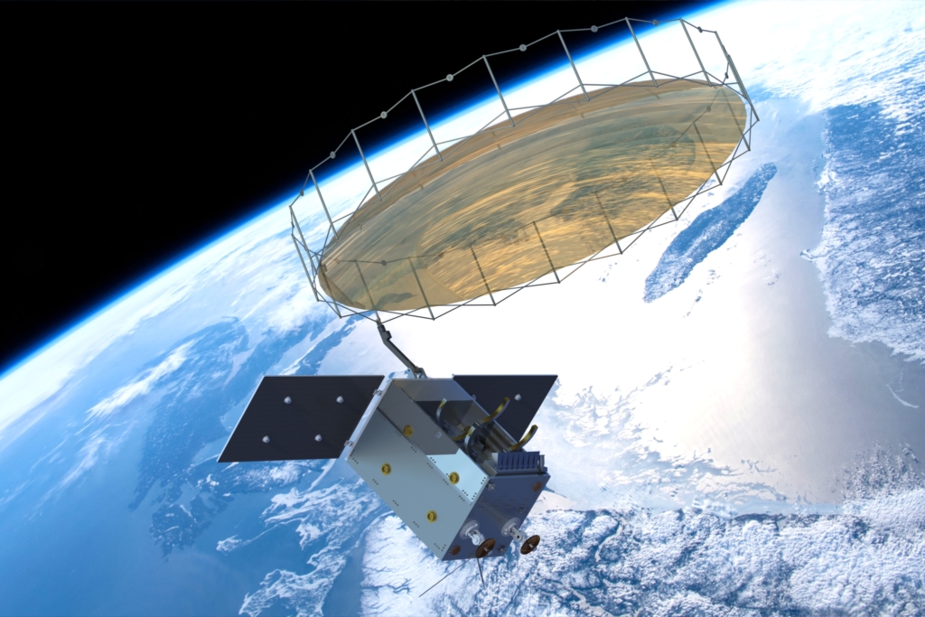
Space Norway currently owns and operates two VDES payloads on the Norwegian Space Agency's NorSat satellites, and plans are underway for a third VDES payload on the ADIS satellite scheduled for launch in 2025.
Kongsberg Discovery Seatex is positioned as an internationally leading provider of both ship equipment and satellite payloads for VDES, and Comrod has developed an entirely new ship antenna with improved performance.
The system specification for VDES is tailored for satellite use, which was an initiative from the European Space Agency (ESA) in 2014.
Significant International Effort
Space Norway has invested significant effort in international bodies such as CEPT (European Conference of Postal and Telecommunications Administrations), ITU (International Telecommunication Union), and IALA to facilitate frequency allocations and standardization of the VDES system.
In preparation for and during the work at the World Radiocommunications Conference in 2019 (WRC-19), Space Norway held CEPT Coordinator role for the agenda item related to the frequency allocations for satellite VDES.
Norway, with Space Norway and the Norwegian Communications Authority, played a crucial role in securing frequency allocations for satellite VDES at WRC-19. This was possible due to extensive and solid groundwork in the form of system development, measurements, and testing of VDES signals using Space Norway's VDES payload on NorSat-2. The work was supported by the European Space Agency, the Norwegian Space Agency, the Norwegian Coastal Administration, and the Norwegian Maritime Authority.
Related articles